Plan: Base & Premium
Live Snow is our name for the latest hour-by-hour snowfall data that we pull from thousands of weather stations across the United States and Canada.
You can use this feature to see how much snow has fallen in near real-time rather than waiting for an "official" measurement from a resort or another data service which often only reports once per day. For example, if you are awake at 5 am, you can view the Live Snow data to see how much snow has fallen since the previous day's afternoon.
The Live Snow feature is unique because most of this weather station is often hard to find with the need to bookmark many links and sift through lots of raw data to figure out how much it snowed. We hope that surfacing this data in an easy-to-use way will help all of us find the best snow.
Please note that this is an experimental feature. Automated snowfall measurements from remote weather stations are sometimes difficult to interpret due to unreliable or 'jumpy' data, and we do our best to programmatically remove inaccurate data.
We use four different pieces of weather station data to report hourly snowfall, and you can tap the "How to read this data" link to see what data was used for the station that you are viewing.
1) Snow Interval: If a weather station offers a measurement of new snow from a "snow board" that is cleared once or multiple times per day, we use these values as they tend to be the most accurate.
2) SWE x SLR: If a weather station measures the "Snow Water Equivalent (SWE)", or the amount of water you would measure if you melted the snow, we multiply this amount by our estimated "Snow to Liquid Ratio" to arrive at an estimate for the amount of snow that fell during the hour. For example, if the SWE was 0.1 and our Snow to Liquid Ratio was 15-to-1, then we would estimate that 0.1 x 15 = 1.5 inches of snow accumulated during that hour. For SNOTEL sites (of which there are about 1,000 across the western United States), we have found that this "SWE x SLR" method is often a little more reliable than the Snow Depth measurements, as the Snow Depth measurements sometimes report less snow than has actually accumulated, especially if the snow quality is light and fluffy.
3) Snow Depth: If a weather station offers a measurement of the total amount of snow on the ground, we use the changes in this measurement to report hourly snow. Note that this measurement can be less reliable than the Snow Interval measurement, but for many weather stations, this is the only available snow measurement.
4) Snow Stake Cams (Powder Vision): We built a system to estimate the amount of snow that accumulates on a snow stake camera every hour. Many ski resorts have snow stake cameras and this allows us to (try to) figure out how much snow falls each hour.
We have algorithms that attempt to remove inaccurate data, and also that choose which of the above methods should be used to report snowfall for that hour. Again, this is an experimental feature, and we will continue to improve on it over time.
Getting Started
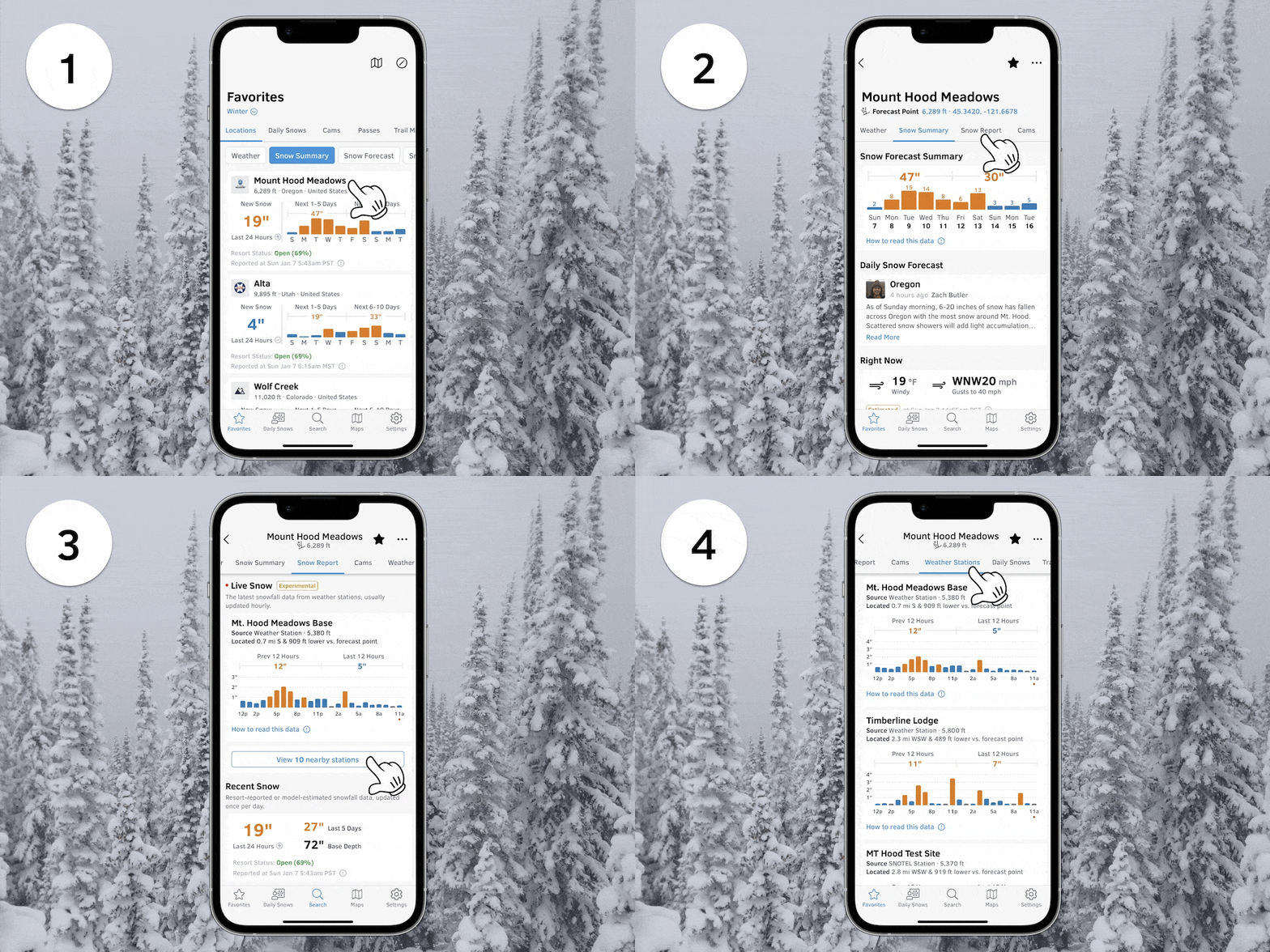
- Go to any location screen.
- Tap the "Snow Report" tab.
- View data from the closest weather station or...
- Tap the "Weather Stations" tab to view all nearby data.

Blue bars indicate snowfall less than 1 inch (2.54 cm) per hour.
Orange bars indicate snowfall greater than 1 inch (2.54 cm) per hour.
Purple bars indicate that mixed precipitation has been detected during that hour.
X icons show that the snowfall data for that hour might be inaccurate/unreliable or is not available.
View → OpenSnow Locations
